Park Ridge, IL near O'Hare Office +1 (773) 853-2672 | Roselle, IL Office +1 (630) 351-9489
Spiewak Consulting
Andrew Spiewak Land Surveyor, Inc.

- Plat of Survey/Boundary
- ALTA/NSPS Land Title Survey
- Condominium Survey
- Topographic Survey
- As-Built Survey / Final Survey
- Construction Survey
- Foundation Staking
- Foundation Location / Spot Foundation
- Subdivision
- Tax Division
- Land Development
- Site Plan
- Elevation Certificate
- Sign Surveys
- Plat of Annexation
- Plat of Easement
- Plat of Vacation
- Wetland Survey
- Boundary Disputes
- Discovery Report
Subdivision
This survey takes a large parcel of land and divides it into smaller parcels of land known as "lots". This usually must conform to the review process, guidelines and jurisdiction of a local agency (often the village, town or county board within whose limits the property is located). The surveyor begins with a boundary survey, and may also be called to provide a topographic survey or ALTA survey. Often a civil engineer will be contracted to create grading plans, storm drainage, utility and street plans.
Sometimes a plat of easement for utilities and rights of way must be created. After design and approval of the subdivision plat, the surveyor may also be involved in construction layout.
Landowners are often surprised to learn that dividing and selling a portion of their property may require a lengthy process, with government approval far from assured. The necessary steps to subdivide the land and the involvement of the community have greatly changed over the years, with state and local regulations increasing in complexity. Essential knowledge includes subdivision title issues, such as land descriptions, encumbrances, and insurance. Spiewak Consulting will help you to navigate the complex maze of platting, subdivision approvals, and title issues.
Section 1270.56 Minimum Standards of Practice

Regency Dr Subdivision Sample
![]() Plat of Subdivision – Regency Dr – Page 1/2
Plat of Subdivision – Regency Dr – Page 1/2
![]() Plat of Subdivision – Regency Dr – Page 2/2
Plat of Subdivision – Regency Dr – Page 2/2

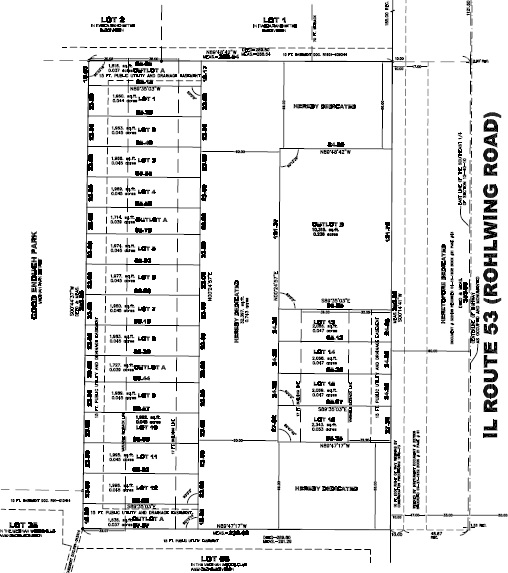
Rohlwing Road Subdivision Sample
![]() Plat of Subdivision – Rohlwing Road
Plat of Subdivision – Rohlwing Road
Vertical Subdivision
The Minimum Standards state the following regarding vertical Subdivisions:
- Vertical subdivisions, i.e., subdivisions that divide property by horizontal, vertical, and oblique planes, require that all exterior boundary corners of the subdivision be monumented at its ground elevation prior to recordation of the subdivision plat.
- The physical features, if any, controlling the limits of the subdivided property must be defined on the subdivision plat.
- The datum used to control the dividing horizontal planes must be defined on the subdivision plat, together with the benchmark used to determine the elevations of these planes.
- The interior corners or any lot or block corners other than those that are required for monumenting the exterior boundary corners do not require monumentation.
Thus, the minimum standards merely touch upon little more than field procedures when it comes to vertical subdivisions.